Menu

Showing posts with label tourism. Show all posts

Explore the Majestic Desert Landscape of Wadi Rum, Jordan

Nestled within southern Jordan lies the dramatic desert valley of Wadi Rum, one of the most spectacular landscapes in the Middle East. With its burnt orange and red sandstone cliffs towering over white sand, Wadi Rum offers unparalleled vistas around each bend. This diverse desert is also infused with rich human history and Bedouin culture. 


The Natural Beauty of Wadi Rum

Wadi Rum's diverse desert terrain comprises not only sand dunes, but also natural rock bridges, canyons, and weathered granite rock formations that astound at every vista. The sharpest rays of sunlight illuminate the valley amid a Martian-like backdrop. Herds of camels are often seen wandering by the orange sands with their Bedouin owners, adding motion to the age-old landscape. The clear night skies also allow stunning star gazing opportunities. 


Rich Human Heritage 

This desert valley contains rock drawings, inscriptions and archaeological sites that date back to prehistoric times. Artifacts show Wadi Rum was traversed by the Nabateans. Later civilizations like the Romans influenced early settlements. Wadi Rum even became the base of Lawrence of Arabia during the Arab Revolt against the Ottoman Empire in 1917-18.


Authentic Bedouin Culture 

Wadi Rum has been home to Bedouin tribes for centuries. Living in goat hair tents, they have survived the desert through their hospitality, story-telling traditions and knowledge of the landscape. Visitors can experience authentic Bedouin culture by staying overnight in one of their camps to witness music, dance, food under the milky way stars.


Top Attractions in Wadi Rum

The highlights and must-see attractions within Wadi Rum include:

- Jebel Um Ishrin - Ascend Jordan's tallest peak for phenomenal views 

- Lawrence's Spring - See petrogylphs near the watering hole used by Lawrence of Arabia

- Khazali Canyon - A dramatic and narrow siq you can hike through 

- Burdah Rock Bridge - An iconic natural rock arch rising massively from the sands

- Lawrence's House - Where Lawrence based his operations in 1917 now containing displays   


Make time when in Jordan to lose yourself in "The Valley of the Moon" - the desert jewel of Wadi Rum awaits with endless beauty and adventure.


Beauty of Wadi Rum

These images are source from Bing.

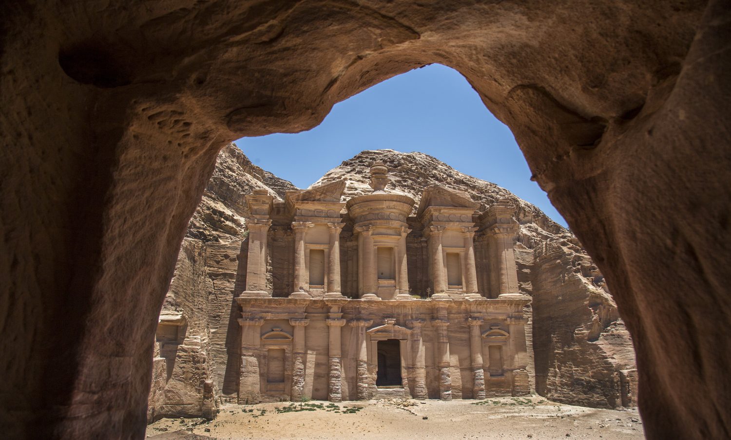
  1. Ad Deir monument in Petra, Jordan
    Ad Deir monument in Petra, Jordan
  2. Facade of Al-Khazneh in Petra, Jordan
  3. Petra, Jordan
  4. Wadi Rum, Jordan
  5. Amman, Jordan
  6. Wadi Rum ('The Valley of the Moon') in Jordan
  7. Ancient ruins in Petra, Jordan

Queen of the Arabian Sea | Kochi

Kochi, a vibrant city in the southwestern Indian state of Kerala. Kochi often referred as the “Queen of the Arabian Sea”. This title revealing Kochi's historical and cultural importance as a major port and trading hub along the Arabian Sea.There are several reasons due to that Kochi is referred as "Queen of the Arabian Sea":

  1. Strategic Location: Kochi has a strategic location along the Arabian Sea coast. Its position makes it a significant port city, historically attracting traders and explorers from around the world. 
  2. Historical Significance: Throughout history, Kochi has been a crucial center for trade and commerce, drawing merchants and seafarers from various parts of the globe. 
  3. Port City Heritage: Kochi has a long history as a port city. The port has played a vital role in the trade of spices, silk, and other commodities, making it a key player in the maritime silk route. 
  4. Cultural Fusion: The city's rich history is marked by the influence of various cultures, including Indian, Arab, Chinese, Dutch, and Portuguese. This cultural amalgamation is reflective of its vibrant and diverse atmosphere. 
  5. Scenic Beauty: The city is known for its picturesque landscapes, with the Arabian Sea providing a stunning backdrop. The serene backwaters, islands, and the historic Fort Kochi add to its charm. 
  6. Tourist Attractions: Kochi is home to several tourist attractions, including the Chinese Fishing Nets, Mattancherry Palace, St. Francis Church, and Jew Town. These landmarks contribute to its status as a tourist hub. 
  7. Culinary Delights:Kochi's cuisine is influenced by its maritime history, featuring an array of seafood dishes. The city is renowned for its culinary delights, attracting food enthusiasts from far and wide. 
  8. Cultural Events: The city hosts various cultural events and festivals, celebrating its diversity. The Cochin Carnival and the Kochi-Muziris Biennale are notable examples. 
Kochi the Queen of Arabian Sea
Picture source: picnicwale.com

Arc de Triomphe 

The Arc de Triomphe is a monument (a kind of gate) stands as a timeless symbol of French history and patriotism, located in Paris to honouring those who fought and died for France.


Arc de Triomphe, Paris 21 October 2010
Source: Wikimedia, Author: Jiuguang Wang, CC BY-SA 2.0

UNESCO World Heritage Sites in Delhi, India

There are three UNESCO World Heritage Sites in Delhi. Those three sites are:

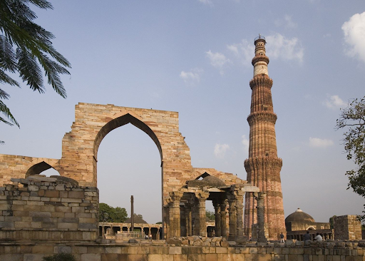
  1. Qutub Minar (declared in year 1993)
  2. Humayun’s Tomb (declared in year 1993)
  3. Red Fort (declared in year 2007)


Qutub Minar, Image Source: AudleyTravel.com


Brick-Hued Hills: A Palette of Nature's Beauty

Nestled between the valleys and under the expansive sky, the brick-hued hills stand as a testament to the awe-inspiring artistry of nature. These unique geological formations, characterized by their warm and earthy tones, evoke a sense of tranquility and connection with the natural world. In this article, we explore the captivating allure of brick-hued hills and their significance in the tapestry of landscapes.

A Painter's Canvas

The brick-hued hills derive their distinctive color from a harmonious blend of minerals, sediments, and geological processes that have unfolded over millennia. The earthy red and brown tones result from the presence of iron oxides and other minerals that have weathered and oxidized over time. As the sun's rays caress these hills, their hues shift and transform, creating a breathtaking spectacle that seems almost otherworldly.

Nature's Sculptors

Geological forces have played a vital role in shaping these brick-hued hills into their current form. Erosion, uplift, and tectonic activity have sculpted the land, revealing layers of sedimentary rock and geological history. These hills often emerge as a result of intricate geological processes, including sediment deposition, compression, and weathering.

Cultural and Ecological Significance

Brick-hued hills hold cultural and ecological significance in various regions around the world. They often serve as iconic landmarks, symbols of resilience, and sources of inspiration for local communities. In some cultures, these hills are associated with ancient legends and myths, enriching the tapestry of human storytelling.

Moreover, these unique landscapes often support diverse ecosystems, housing a variety of flora and fauna adapted to their distinct geology and climatic conditions. The undulating contours of brick-hued hills provide habitats for plant species that thrive in arid or semi-arid environments. The interplay between the terrain, soil composition, and sunlight creates microhabitats that sustain life in harmony with the land.

Visions of Tranquility

The allure of brick-hued hills extends beyond their visual splendor. They offer a sanctuary for those seeking solace and contemplation. The tranquility of these landscapes invites travelers and explorers to immerse themselves in the raw beauty of the earth, allowing them to connect with nature on a profound level.

Preserving Natural Treasures

As we marvel at the captivating beauty of brick-hued hills, it is imperative to recognize the importance of environmental stewardship. These unique landscapes are fragile and vulnerable to human activities and climate change. Conservation efforts are crucial to ensure that future generations can continue to be enchanted by the timeless allure of these natural wonders.

The brick-hued hills stand as a testament to the remarkable artistry of nature, showcasing the harmonious interplay between geology, minerals, and time. Their warm and earthy tones invite us to pause and reflect on the intricate beauty that surrounds us. As we traverse the landscapes of brick-hued hills, we are reminded of the boundless wonders that the natural world has to offer.

Jama Masjid, Delhi

Jama Masjid - جامع مسجد , Shahjahanabad, Delhi-6

The Largest Masjid/Mosque of India was built by Mughal Emperor Shah Jahan between 1644 and 1656. Masjid is established in front of Red Fort which was used for administration during the Mughal era. When Shah Jahan decided to move his capital city from Agra to somewhere then he ordered their ministers to find a place which is in between Agra and Lahore so we can cover and rule all over India. so select a central location from where can keep their eyes around all over the nation. Then they found the city Delhi which is located on the bank of the river Yamuna.

Then ShahJahan ordered to plan a city which should similar to Fatehpur & Sikri. Fatehpur and Sikri are also to walled city which was built by his grand father Jalaluddin Muhammad Akbar. Hence they proposed a walled city and named it Shahjahanabad.

This Mosque was also built at that time and this is in their panned city, and situated in front of the Red Fort, Delhi.
Central Dome

Pavillion and Exit Gate Number 1 

Small Dome

Hauz for Ablution and two main gates

Main Entrance of Masjid

Complete view of Masjid from Aangan

large View of Masjid and world map drawn over the white marble


#Masjid #India #Tourism #Heritage #Architecture #Islam


How to reach?

Airport: IGI (Indira Gandhi International Airport, New Delhi)
Metro Station: Jama Masjid Metro Sattion(Heritage Line/Voilet Line)


Tughlaqabad Fort

Tughlaqabad: Though it is widely believed that the fort city named Tughlaqabad was constructed in six years between 1321 and 1327, anyone who visited the 7 sq.km wide magnificent ruins.

The fort stretches across nearly 7km on Qutab-Badarpur road. Initially built by Ghiyas-ud-Din Tughlaq, the father of the dynasty, the structure was primarily conceived to serve both as a defense mechanism and an imposing capital synchronously. Octagonal in shape and divided into three sections, the fort’s ramparts are almost 15 meters in height. Records say that the citadel had 52 gates in the past though only 13 are seen now.

The city of Thughlakabad spread in an area of about 300 acres (121.40 hectares) and enclosed within a fortification wall is interspersed with bastions at regular intervals and gateways. The gate way complexes are quite elaborate since group of four, six or eight circular chambers about 8m (26.24 ft) in diameter and about 10 m (32.81 ft) in depth were provided to store grains for emergency. These grain silos are specific to Tughlakabad fort. The city had well-laid grid plan of roads which connected the gateways from one end to another. The housing blocks were planned along the roads. Entry to the citadel was through the city. The city was also connected with Adilabad fort, which was later made by Muhammad Bin Tughlak, son of Giyasuddin.


Cairo City, Egypt

CAIRO

Cairo is a vibrant, exhilarating, exotic, fascinating and welcoming city. Home to the best Pharaonic, Coptic and Islamic sights in Egypt, this city is where you never know what incredible, half-forgotten monument you might stumble across while wandering around. Enjoy the Nile view from your hotel room balcony, visit the capital's medieval markets by Khan El-Khalili, or walk down the Nile promenade. There are also plenty of cinemas, theatres and modern malls. Go for an opera or enjoy oriental music dance shows. Good for short breaks and long stays; you’ll get to see the Giza Pyramids, thousands of ancient artifacts in the Egyptian Museum of Antiquities and much more.

Moreover, Cairo is for everyone, there are plenty of mid range and budget accommodations to choose from. Pick a charming boutique hotel in the heart of downtown or indulge in utter luxury in one of the city’s most luxurious establishments. These usually house professional Spas and wellness centres where you’ll be treated like royalty. There are more than 75 four and five-star hotels in Cairo, which all offer stunning views over amazing landmarks such as the majestic Nile, the Pyramids, beautiful parks and gardens, and upscale clubs and compounds.

The weather in Cairo is moderate and low in humidity at almost any time of the year, except for some specific times in summer. Highs of 36°C are common in July and lows of 21°C have been witnessed; the winter months in Cairo, especially January, are much more pleasant with temperatures ranging between 21°C and 15°C. Accommodation by the Nile offers some relief from the summer heat due to the lovely breeze that comes from the river. In March, April, and June the Khamaseen winds blow from the desert bringing with them higher temperatures and sand. - See more at: http://en.egypt.travel/city/index/cairo#sthash.rXSqRXyS.dpuf
     Cairo is a vibrant, exhilarating, exotic, fascinating and welcoming city. Home to the best Pharaonic, Coptic and Islamic sights in Egypt, this city is where you never know what incredible, half-forgotten monument you might stumble across while wandering around. Enjoy the Nile view from your hotel room balcony, visit the capital's medieval markets by Khan El-Khalili, or walk down the Nile promenade. There are also plenty of cinemas, theaters and modern malls. Go for an opera or enjoy oriental music dance shows. Good for short breaks and long stays; you’ll get to see the Giza Pyramids, thousands of ancient artifacts in the Egyptian Museum of Antiquities and much more.

Moreover, Cairo is for everyone, there are plenty of mid range and budget accommodations to choose from. Pick a charming boutique hotel in the heart of downtown or indulge in utter luxury in one of the city’s most luxurious establishments. These usually house professional Spas and wellness centres where you’ll be treated like royalty. There are more than 75 four and five-star hotels in Cairo, which all offer stunning views over amazing landmarks such as the majestic Nile, the Pyramids, beautiful parks and gardens, and upscale clubs and compounds.

The weather in Cairo is moderate and low in humidity at almost any time of the year, except for some specific times in summer. Highs of 36°C are common in July and lows of 21°C have been witnessed; the winter months in Cairo, especially January, are much more pleasant with temperatures ranging between 21°C and 15°C. Accommodation by the Nile offers some relief from the summer heat due to the lovely breeze that comes from the river. In March, April, and June the Khamaseen winds blow from the desert bringing with them higher temperatures and sand.

Cairo view from Cairo Tower-3


Cairo is a vibrant, exhilarating, exotic, fascinating and welcoming city. Home to the best Pharaonic, Coptic and Islamic sights in Egypt, this city is where you never know what incredible, half-forgotten monument you might stumble across while wandering around. Enjoy the Nile view from your hotel room balcony, visit the capital's medieval markets by Khan El-Khalili, or walk down the Nile promenade. There are also plenty of cinemas, theatres and modern malls. Go for an opera or enjoy oriental music dance shows. Good for short breaks and long stays; you’ll get to see the Giza Pyramids, thousands of ancient artifacts in the Egyptian Museum of Antiquities and much more.

Moreover, Cairo is for everyone, there are plenty of mid range and budget accommodations to choose from. Pick a charming boutique hotel in the heart of downtown or indulge in utter luxury in one of the city’s most luxurious establishments. These usually house professional Spas and wellness centres where you’ll be treated like royalty. There are more than 75 four and five-star hotels in Cairo, which all offer stunning views over amazing landmarks such as the majestic Nile, the Pyramids, beautiful parks and gardens, and upscale clubs and compounds.

The weather in Cairo is moderate and low in humidity at almost any time of the year, except for some specific times in summer. Highs of 36°C are common in July and lows of 21°C have been witnessed; the winter months in Cairo, especially January, are much more pleasant with temperatures ranging between 21°C and 15°C. Accommodation by the Nile offers some relief from the summer heat due to the lovely breeze that comes from the river. In March, April, and June the Khamaseen winds blow from the desert bringing with them higher temperatures and sand. - See more at: http://en.egypt.travel/city/index/cairo#sthash.rXSqRXyS.dpuf

City of the Dead, Cairo, Egypt


The 6 October Bridge over the Nile River, Cairo, Egypt


Cairo University, Cairo

Kaziranga National Park

Kaziranga National Park is spread over 858 sq.kms and is located in the floodplains on both sides of the Brahmaputra. Patches of mixed deciduous forests are interspersed with vast stretches of savannah grasslands, wetlands and chars of river islands formed by the shifting course of the Brahmaputra.
The park is divided into five ranges - Central (entry point at Kohora), Western (entry point at Bagori), Eastern (at Agratoli), Western-most Burha Pahar (at Ghorakati) and Northern. The first four lie on the southern side of the river while the last is on the northern bank.
A memorable way of exploring Kaziranga is on eleplant-back as these gentle creatures tread through the tall grass. The park's prized possessions, the rhinos, are usually found in good numbers grazing with deer and buffaloes.
Another option is to see the park is to take the jeep safari which is also highly recommended, as it offers the added benefit of covering a vast expanse in a relatively short span of time.
While on safari, visitors to the park are well advised not only to abide by park etiquettes but also to bear in mind its conserbation history, officially counted as the most successful conservation initiative in the sub continent in the 20th century (Kaziranga Centenary: Celebrating the Century's Greatest Success Story, 2005)
Originally established as a reserve forest in 1908, Kaziranga was declared a sanctuary in 1916 to counter extensive poaching of the rhinoceros. In 1974, the Indian Government demarcated the present area as a national park. Then, in 2007, it was declared a tiger reserve under the Central Government's Project Tiger scheme.
The Park is the abode to more than 70% of One Horned Rhinoceros in the world. Highest density of tigers' prey including the large prey biomass of tiger found in the country. Harbours more than 60% of India's wild buffalo population along with the only population of the Eastern Swamp deer and seven species of turtles and tortoises. The other important wildlife found are - Leopard, Fishing Cat, other Lesser cats, Large Indian
Civet, Small Indian Civet, Sambar, Barking deer, Hog deer, Gaur, Hog Badger, Hoolock Gibbon, Capped Langur, Assamese Macaque, Rhesus Macaque, Sloth Bear, Gangetic Dolphin and Otter etc
The park also has a sizeable population of birds. Home to 25 Globally Threatened and 21 Near Threatened species of birds. Huge flocks of pelicans and rose-ringed parakeets can be spotted here besides crested serpent eagles, grey-headed fishing eagles, red jungle fowl, Bengal floricans, bar-headed geese and whistling teals.
More than 150 perennial water bodies are located inside the Park, where water level fluctuates temporally resulting in the generation of a very rich aquatic floral diversity. More than 32 species of flora have so far been identified.  More than 60 species of fishes have been recorded and is the breeding ground of many of the local species.


How to Reach : Rowraiah (Jorhat) is the nearest Airport which is 97 Kms. away and LGBI Airport (Guwahati) is 239 Kms. away. The road distances from nearest cities & towns to Kohora are : from Jorhat is 89 Kms., from Nagaon is 96 Kms., from Guwahati is 219 Kms., from Golaghat is 73 Kms. and from Bokakhat is 21 Kms.
Contact Person: Director, Kaziranga National Park
Contact Numbers: +91 3776-268095 / +91 3776-268086
Best season to visit: November to April.


Major In World's


Oceans of the World (by Size)
  • Pacific (155,557,000 sq km)
  • Atlantic (76,762,000 sq km)
  • Indian (68,556,000 sq km)
  • Southern (20,327,000 sq km)
  • Artic (14,056,000 sq km)
Ocean's Greatest Depths
  • Mariana Trench, Pacific Ocean 35,827 ft
  • Puerto Rico Trench, Atlantic Ocean 30,246 ft
  • Java Trench, Indian Ocean 24,460 ft
  • Arctic Basin, Arctic Ocean, 18,456 ft
Major Seas (by Size)
  • South China (2,974,600 sq km)
  • Caribbean (2,515,900 sq km)
  • Mediterranean (2,510,000 sq km)
  • Bering (2,261,100 sq km)
  • Gulf of Mexico (1,507,600 sq km)
  • Arabian Sea (1,498,320 sq km)
  • Sea of Okhotsk (1,392,100 sq km)
  • Sea of Japan (East Sea - 1,012,900 sq km)
  • Hudson Bay (730,100 sq km)
  • East China (664,600 sq km)
  • Andaman (564,900 sq km)
  • Black (507,900 sq km)
  • Red (453,000 sq km)
Major Rivers (by length)
  • Nile, Africa (6,825 km)
  • Amazon, South America (6,437 km)
  • Chang Jiang (Yangtze), Asia (6,380 km)
  • Mississippi, North America (5,971 km)
  • Yenisey-Angara, Asia (5,536 km)
  • Huang(Yello), Asia (5,464 km)
  • Ob-Irtysh, Asia (5,410 km)
  • Amur, Asia (4,416 km)
  • Lena, Asia (4,400 km)
  • Congo, Africa (4,370 km)
  • Mackenzie-Peace, North America (4,241 km)
  • Mekong, Asia (4,184 km)
  • Niger, Africa (4,171 km)
Major Lakes (by Size)
  • Caspian Sea, Asia-Europe (371,000 sq km)
  • Superior, North America (82,100 sq km)
  • Victoria, Africa (69,500 sq km)
  • Huron, North America (59,600 sq km)
  • Michigan, North America (57,800 sq km)
  • Tanganyika, Africa (32,900 sq km)
  • Baikal, Asia (31,500 sq km)
  • Great Bear, North America (31,300 sq km)
  • Aral Sea, Asia (30,700 sq km)
  • Malawi, Africa (28,900 sq km)
  • Great Slave, Canada (28,568 sq km)
  • Erie, North America (25,667 sq km)
  • Winnipeg, Canada (24,387 sq km)
  • Ontario, North America (19,529 sq km)
Deepest Lake (by Greatest Depth)
  • Baikal, Russian Fed. (5,315 ft)
  • Tanganyika, Africa (4,800 ft)
  • Caspian Sea, Asia-Europe (3,363 ft)
  • Malawi or Nyasa, Africa (2,317 ft)
  • Issyk-Kul, Kyrgyzstan (2,303 ft)
Tallest Mountains (on each Continent)
  • Mount Everest 8859 m - Asia
  • Aconcagua 6959 m - S. America
  • Mount McKinley 6194 m - N. America
  • Mount Kilimanjaro 5963 m - Africa
  • Mount Elbrus 5633 m - Europe
  • Puncak Jaya 4884 m - Oceania
  • Vinson Massif 4897 m - Antarctica
Oldest Countries
  • San Marino (301 AD)
  • France (486 AD)
  • Bulgaria (632 AD)
  • Denmark (950 AD)
  • Portugal (1143 AD)
  • Andorra (1278 AD)
  • Switzerland (1291 AD)
Youngest Countries
  • Montenegro (July 2006)
  • Serbia (July 2006)
  • East Timor (2002)
  • Palau (1994)
  • Czech Republic (1993)
  • Eritrea (1993)
  • Slovakia (1993)
  • Bosnia/Hertzegovina (1992)
Continents of the World (by Size)
  • 1 Asia (445,579,000 sq km)
  • 2 Africa (30,065,000 sq km)
  • 3 North America (24,256,000 sq km)
  • 4 South America (17,819,000 sq km)
  • 5 Antarctica (13,209,000 sq km)
  • 6 Europe (9,938,000 sq km)
  • 7 Australia/Oceania (7,687,000 sq km)
Continents by Population
  • 1 Asia
  • 2 Africa
  • 3 Europe
  • 4 North America
  • 5 South America
  • 6 Australia/Oceania
  • 7 Antarctica
Continents by number of Countries
  • 1 Africa (53)
  • 2 Europe (46)
  • 3 Asia (44)
  • 4 North America (23)
  • 5 Oceania (14)
  • 6 South America (12)
Countries with Most land Boundaries
  • China - 14
  • Russian Federation -14
  • Brazil - 10
  • Congo, Germany and Sudan - 10
  • Austria, France, Tanzania, Turkey and Zambia - 8
Top 10 Tallest Mountains
  • Mount Everst, 8850m (29035 ft) - Nepal
  • Qogir (K2), 8611 m (28250 ft) - India
  • Kangchenjunga 8586 m (28169 ft) - Nepal
  • Lhotse, 8501 m (27929 ft) - Nepal
  • Makalu I, 8462 m (27765 ft) - Nepal
  • Cho Oyu, 8201 m (26906 ft) - Nepal
  • Dhaulagiri, 8167 m (26794 ft) - Nepal
  • Manaslu I, 8156 m (26758 ft) - Nepal
  • Nanga Parbat, 8125 m (26658 ft) - Pakistan
  • Annapurna I, 8091 m (26545 ft) - Nepal


Tourism in Karnataka

Tourism In Karnataka

Karnataka has been ranked as fourth most popular destination for tourism among states of India. It has the highest number of national protected monuments in India, at 507.
Kannada dynasties like Kadambaseastern GangasChalukyasRashtrakutasHoysalasVijayanagaras and the Kingdom of Mysore ruled from what is today Karnataka. They built great monuments to Buddhism, Jainism and Hinduism. These monuments are preserved at BadamiAiholePattadakalMahakutaHampiLakshmeshwarSudiHooliMahadeva Temple (Itagi),DambalLakkundiGadagHangalHalasiGalaganathaChaudayyadanapuraBanavasiBelurHalebiduSringeriShravanabelagolaSannatiNanjangudMysoreNandi HillsKolarMudabidri,Gokarna, Bagali, Kuruvatti and many more. Notable Islamic monuments are present at BijapurBidarGulbargaRaichur and other part of the state. Gol Gumbaz at Bijapur, has the second largest pre-modern dome in the world after the Byzantine Hagia SophiaKarnataka has two World heritage sites, at Hampi and Pattadakal. Bellary one of the historical place to see and charist, we can see the forts which were built by the great Tippu Sultan for protection.
Karnataka is famous for its waterfalls. Jog falls of Shimoga District is second highest waterfalls in Asia. This state has 21 wildlife sanctuaries and five National parks and is home to more than 500 species of birds. Karnataka has many beaches at KarwarGokarnaMurdeshwaraSurathkal. Karnataka is a rock climbers paradise. Yana in Uttara Kannada, Fort in Chitradurga, Ramnagara near Bengaluru district, Shivagange in Tumkur district and tekal in Kolar district are a rock climbers heaven. Utsav Rock Garden in Shiggaon, Uttar Kannada.

List of Palaces:

Hill Stations:


List of Wildlife Sanctuaries: